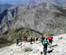
Fundamentally, your choice here is between self-guided walks, usually shorter in distance and closer to human habitation, and accompanied walks, possibly taking all day, and heading up well into the hills and mountains that form such a dramatic backdrop to Nerja.
We pride ourselves that the self-guided walks that we describe have all been researched by ourselves (and in many cases all or part of these are of our own creation), and continue to be checked for feasibility, and we believe that the information that we supply is quite sufficient for you to undertake any of these walks by yourself.
However there are several reasons why we sometimes also recommend accompanied walks. You may wish to walk with a larger group, or benefit from being out with somebody who knows the area and its history well, and who can therefore enrich your experience considerably. The other element is that of safety. We are not suggesting that the actual terrain is dangerous (and there are no brown bears waiting to attack you), but it is wild country up in the mountains, with numerous ancient mule paths and the like, where it is easy for even the most experienced, and GPS-equipped, walker to get lost. For example, as little ago as 2011 a Dutch lady went missing near the source of the Rio Chillar, surviving for 19 days before, thankfully, being rescued. At the very least don't walk up here just by yourself!
There are a number of walking clubs in the area, ranging from the highly professional to the very small and domestic, together with people offering professional guiding services. However the latter do seem to come and go, and we suggest that you consult the Nerja Tourist Office, located in the Town Hall building in C/ Carmen.
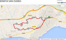
Our own self-guided walks contain a full description of the route to take, together with a link to a (zoomable) Google map (on the MapMyWalk website), with kilometer distance markers, that will further enable you to relate the text instructions to the actual terrain. As it stands this feature probably takes our walk descriptions beyond any others that you might try out. The MapMyWalk link top right describes the various ways in which you can glean information from this on-line map, and indeed download this information onto your own GPS device to accompany you on your walk.
Mind you, Elma Thompson once reported that she was sitting close to a viewpoint on one of her routes, when a walking group came past, heads down, eyes locked onto their GPS devices, who never even saw her - or indeed the superb views that Elma so relishes. This is not for us either, being too reminiscent of those many people who roam our city streets, immersed in their smartphones, and oblivious to passers-by.
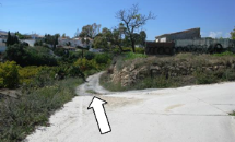
Therefore, and as already noted, as a further bonus to our own guests, who are booking their walking holiday directly through ourselves, we have produced a downloadable PDF that already contains printed versions of the maps, together with photographs of key junctions (with arrows added where necessary, as depicted opposite) and of the surrounding scenery, together with historical and other information.
As you will see, most of the self-guided walks begin at the entrance to the El Capistrano Village development, since this where most of our rental properties are located (see section on Accommodation). Hence, and the same must apply to all walk descriptions anyway, if you are not staying here then you will either need to make your way here, or work out how to join up with the route at a point convenient to you.
One cautionary point to mention that it is inadvisable to select a route, and then choose to do it back-to-front instead: the directions just aren't going to work. For example, you might be heading along a straight path, as shown below right, with, at one point, another path coming in from one side at an acute angle.
Your route description won't mention this side path, since it clearly isn't going to affect the route taken. However if you were trying to undertake the route in the reverse direction, again as illustrated opposite, you would be faced with a 'Y' junction, with no idea which fork to take.
It is also worth noting here that, at various points, in the middle of various walks, you may find yourself walking along a stretch of the celebrated ‘Gran Senda de Malaga’ walking route. Designated by the code GR-249 (from ‘Gran Recorrido’, which means ‘long distance path’) this particular route begins in Malaga and then covers 35 daily stages, each averaging around 20 km in length, heading along the coast from Malaga to Nerja, then turning north into the countryside through Frigiliana and then Competa, before sweeping further north and then west, before descending to the coast again close to Estepona, and then heading back to its start point of Malaga.
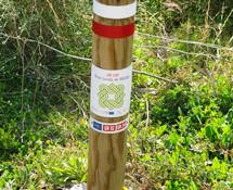
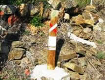
Given the above itinerary, it is not surprising that a good number of our walks encounter the Gran Senda route. However it is often only for a short stretch, before branching off again. The Gran Senda route is characterised by marker posts of the type shown above right, with parallel red and white markings. However, at junctions where the Gran Senda route deviates from ours you will usually find yourself warned of this by seeing a marker bearing a red and white cross, as is also shown opposite. Hence it is not a good idea to pay too much attention to these markers, in case you get misled.