Distance: 3 km (one way) Time: 1 hour Difficulty Rating: Medium
MapMyWalk Link PDF Link (available to SpainAway guests)
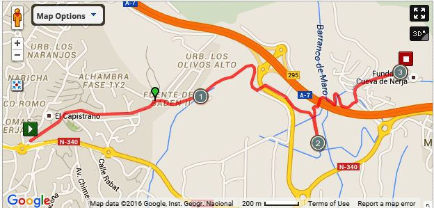
The Caves of Nerja are readily reached by road, either on foot or by car or bus. Simply take the main N340 road east of Nerja in the direction of Maro, swinging left at the roundabout at the turn off to Maro, up to the car park at the entrance to the Caves themselves. In addition to being well worth a visit in their own right, the Caves are the starting point for a number of walks heading north and west from here.
However, if walking is your main interest, then there is an alternative route that takes you to the Caves entirely through the countryside - and some spectacular countryside at that.
The map below shows the route in its entirety, with km markers inset. You can also link to the online version of this map, located on the MapMyWalk website, with the ability to zoom in onto much finer details and so on, as described in our introduction. The link details are given above.
Starting, as usual, from the entrance to El Capistrano, take the road off to the right – Via Romana – heading on down until you reach the end of the row of houses on your right, at the point where C/ Europa turns off to the right. However keep straight on here until very shortly you reach a three-way junction marked with a plaque saying Fuente del Baden, Fase II, Cuesta Colarado. Take the right of these three routes, onto a dirt road, and then in about 5 metres bear left alongside a white wall to your left hand side.
Continue until you reach a grove of pine and eucalyptus trees straight ahead. Before entering these turn right, heading uphill with a sandy cliff with pine trees on top on your left, heading up between a pylon on the left and a phone mast on the right. At the top of this track you reach some broken down walls that mark the boundary of the San Joaquin Sugar Mill. Slightly further on there is an underpass off to your left that passes under the slip road down from the motorway. Take this underpass and then follow the road around to the right (ignoring a turn to the left that takes you underneath the motorway itself).
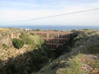
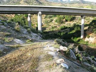
At a fork a short distance beyond, by the side of an old electricity hut, now a store-place, keep left, heading towards, and keeping just to the left of, a telephone mast. The main track swings sharply to the right as you approach the edge of the barranco, or valley, heading in the direction of the Puente de Aguila aqueduct, picture above left. It is in fact worth taking the short detour to take a closer look at this aqueduct. However for the Caves take the route to the left down into the barranco and underneath the motorway, picture above right. At the bottom the track forks right, up by the side of the motorway, and then swings left, joining the main road up to the Caves just below the Hotel Al-Andalus. It is then a short walk uphill to the entrance to The Caves themselves
On returning to Nerja you may prefer to head down to the main N340 road, and then just walk down along this until reaching El Capistrano once more.