via Arroyo del Meli
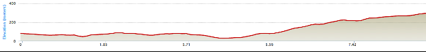
Distance: 9 km Time: 3 1/2 hours Difficulty Rating: Medium
MapMyWalk Link PDF Link (available to SpainAway guests)
The early part of this route is identical to that of the Arroyo del Puerto route, described elsewhere, and indeed the beginning of the Nerja – Frigiliana Route (3). However it takes a more westerly route than the latter, passing through very different countryside, inevitably joining up again close to Frigiliana.
As explained above, the early part of this route is identical to that at the beginning of the 'Arrtoyo del Puerto' route described elsewhere. Hence, rather than repeat everything here, we will begin by referring you to this section of the website.
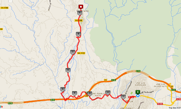
The routes diverge after about 4.3 km, as you dip down underneath the motorway on reaching the riverbed of the Rio Seco II. Its name means ‘Dry River’, and there may well be little or no water flowing along its bed, but in any event if you turn left underneath the motorway and then follow the road to the right, it will take you over the river on a substantial bridge. You should then turn right upriver, passing under the motorway again, but then continuing straight on, leaving the motorway behind. Soon after passing under a pipe bridge overhead, you will reach a bridge back across the river to your right. Take this bridge, noting signs for ‘Cortijo Maria Gomez’ and ‘Villa Elena’ immediately on its far side. Continue along for quite a while, bearing right at an electricity pylon. This whole route at this point is quite seriously uphill.
At a junction further on, with, among others, Villa Las Dos Hermanas to your right, continue on heading upwards, ignoring a turn off to your left. You will then reach a junction, marked on Google maps as ‘Cortijo Pino No 8’. Continue straight on here up the hill for about a km, passing through the urbanisation Las Lomas, and keeping to the left on the main road, until you reach the main Nerja – Frigiliana road at the top, by a bank of letter boxes. This is also where the Nerja – Frigiliana Route (3) comes in. On reaching this main road, turn leftheading down hill to the hamlet of La Molineta.
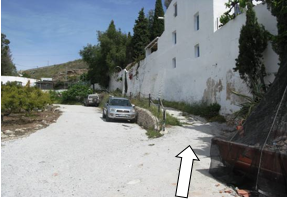 At the point that you reach La Molineta you are also joining in on the final stretch of the Nerja – Frigiliana (1) route. At this point you could then just head off up the main road, noting further splendid views to your right, across the valley, until you reach the roundabout at the entrance to the new village, where you should take the left hand route, or ring road, taking you to the start/end point of all Frigiliana walks, just below the old sugar factory. However a slight deviation is possible, that cuts off a large corner of the main road (and avoids the fact that there is no pavement to walk on during this stretch), wherein you turn right immediately on leaving the exit from the hamlet, and then right again, picture above, The track winds up for something like 200 m, before re-joining the main road above. Now continue on up to Frigiliana.