Distance: 10 km Time: 3 hours Difficulty Rating: Easy
MapMyWalk Link PDF Link (available to SpainAway guests)
This walk combines two of Elma Thompson’s classic Nerja walks, described in her NE/01 and NE/05 booklets.
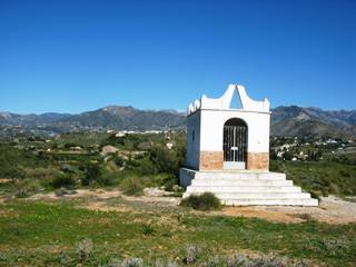
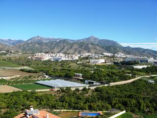
The route takes you out west of Nerja, parallel to the coast road, taking in the Ermita de San Isidro along the way. The Ermita is a small chapel, or shrine, located on top of a decent-sized ridge, giving some excellent views of Nerja and the surrounding countryside. San Isidro is the patron saint of farm workers, and celebrations in his honour take place throughout Spain on the 15th of May each year.
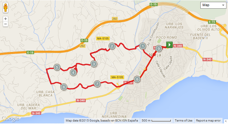
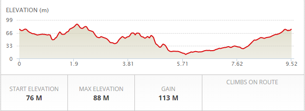
The map below shows the route in its entirety, with km markers inset, together with an indication of the elevation reached during the walk. You can also link to the online version of this map, located on the MapMyRide website, with the ability to zoom in onto much finer details and so on, as described in our introduction. The link details are given above.
As usual our starting point is the entrance to El Capistrano, from where we take a route down to the bed of the River Chillar which avoids going through town, and then strike out west along a country road (the Castillo Alto) until we reach the foot of the ridge upon which the Ermita is situated. The path up to the top is then readily negotiable on foot. A word of warning, though, Google has wrongly identified the site of the Ermita - it's actually a short distance before the building labelled as such.
The actual route taken differs from that used in the past, since the latter now passes through a rather unattractive industrial estate. However we have been able to research a route that incorporates a very old and little-used track that, almost unseen, winds its way through a mixture of small crop-growing areas, and new developments, to emerge on the main Nerja-Frigiliana Road, higher up than previously, thus avoiding the industrial estate..
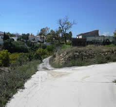 The walk itself heads down from El Capistrano on the road into town, turning right onto C/ Picasso just below the roundabout below Supersol. Follow this road as it heads into the country, dropping down to meet the bed of the Rio Chillar. Cross the (very shallow) river at this point, and then bear left to head up the hillside opposite on a concrete road. Soon after reaching the top this road swings right, as shown in the picture to the left, but you should go straight on here, along a rough track (keeping to the right of a 'Senda de Malaga' waymarker). The track passes down into a valley and then up the other side, emerging onto the 'El Cielo Exotica' urbanisation. Turn right on hitting the road here and follow it round until you reach the main Nerja-Frigiliana road, at a roundabout.
 Cross straight over here and follow the road down, ignoring turns off to the right. At the bottom of the hill turn left up towards the "Punto Limpio", and follow around the side of this, until you reach a T-junction where you need to turn right (passing a 20 km/hour sign on your right) getting your first sighting of the Ermita, on the top of the ridge ahead.
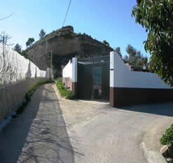
After about 700 metres the road makes an abrupt 90 degree left turn, and shortly after this you are then faced with a fork in the road. It is now necessary to take the left hand fork, onto an unmade road that passes below a sand cliff on your right (see picture right). After a short distance the road widens briefly, forming a sort of layby, and here you should turn right, virtually doubling back on yourself, but climbing up the hillside. Following this track round brings you out onto the top of the ridge, with the Ermita straight ahead.
Cross straight over here and follow the road down, ignoring turns off to the right. At the bottom of the hill turn left up towards the "Punto Limpio", and follow around the side of this, until you reach a T-junction where you need to turn right (passing a 20 km/hour sign on your right) getting your first sighting of the Ermita, on the top of the ridge ahead.
After about 700 metres the road makes an abrupt 90 degree left turn, and shortly after this you are then faced with a fork in the road. It is now necessary to take the left hand fork, onto an unmade road that passes below a sand cliff on your right (see picture right). After a short distance the road widens briefly, forming a sort of layby, and here you should turn right, virtually doubling back on yourself, but climbing up the hillside. Following this track round brings you out onto the top of the ridge, with the Ermita straight ahead.
After enjoying the views from here retrace your steps back down the hill, and then back along the road to the junction with the main concrete route. Here you take the other fork that you ignored previously (i.e. simply turn left at this point) and continue on downhill, keeping to the main road, for quite a while until you reach the Rio Seco. At this point cross over onto the far bank following the road, and then turn left at this point, following the river downstream on its west side. After about 300 metres you will see a fairly wide (car width) bridge back over to the other side of the river, with blue painted railings, and electricity lines paralleling its direction overhead. Take this turning, onto the Camino de Enmedio, and then simply follow this concrete road, through various avocado and lemon plantations, and the like, until you emerge onto the main roundabout at the bottom of the Frigiliana-Nerja road, at the entrance to Nerja. From here turn left in order to follow the main road back up to El Capistrano.
A very graphic account of the plant life to be found in this area is given by Tony Allen in a 2006 article in Soltalk.