Distance: 14 km Time: 5 hours Difficulty Rating: Medium to Hard
MapMyWalk Link PDF Link (available to SpainAway guests)
This walk, which is almost entirely based on Elma Thompson’s TC/21 walk, starts off in Torrox Costa from the junction of the Avenida del Faro (the road leading down to the lighthouse) and the main Nerja-Torrox Costa road, just before the main roundabout at the entrance to Torrox Costa, coming from the direction of Nerja. It then crosses the main ridge in-between Torrox and Nerja.
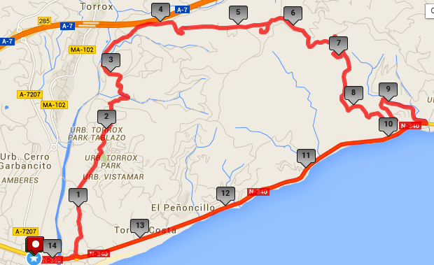
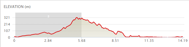
The map below shows the route in its entirety, with km markers inset, together with an indication of the elevation reached during the walk. You can also link to the online version of this map, located on the MapMyWalk website, with the ability to zoom in onto much finer details and so on, as described in our introduction. The link details are given above.
From the top corner of the road above head back along the main road in the direction of Nerja, and, after crossing over a dry river bed, turn left across a zebra crossing onto the other side of the road. Turn right here, and in a hundred metres or so there is a rough track off to the left, heading up the hillside, which you should take. Continue on up this track, ignoring the turns off to right and left.. After a while you will enter into the Torrox Park urbanisation, On reaching a T-junction, with a bar on the left, turn left here, up a short rise, turning right at the top.
 As you continue on along this road you will see, way ahead of you to the right, the crest of a hill bearing a number of red and white radio pylons, which is where we are headed for. Coming to the far end of the Torrox Park urbanisation, continue straight on.
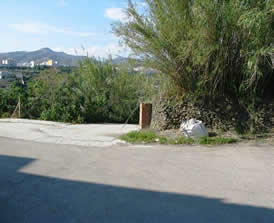
At the end, at just under 2 ½ km, there is an apparent T-junction, with a road off to the right, and a car parking area to the left. However here you need to make a brief dogleg to the left and then actually head straight on, keeping just to the left of a small brick pillar, as shown here.
As you continue on along this road you will see, way ahead of you to the right, the crest of a hill bearing a number of red and white radio pylons, which is where we are headed for. Coming to the far end of the Torrox Park urbanisation, continue straight on.
At the end, at just under 2 ½ km, there is an apparent T-junction, with a road off to the right, and a car parking area to the left. However here you need to make a brief dogleg to the left and then actually head straight on, keeping just to the left of a small brick pillar, as shown here.
Follow this track down, keeping to the main track throughout, eventually reaching a house labelled ‘F Cid’, at which point you need to turn left, the track then heading down to reach the main road, just in front of an irrigation works. Turning right here, and heading up this road you can see the viaduct ahead that carries the motorway, but you need to turn right, parallel to this, in between two sets of electricity pylons. Keep straight on up this track, heading towards the edge of the motorway along a concrete track. You will then pass a GR -249 Senda de Malaga route marker on your left hand side, the track then leading steeply upwards, parallel to the motorway, and then swinging up even more steeply to the right, becoming quite a tough climb. Shortly after passing the Villa Blanca, to your right, the track forks three ways, and you should take the second on the right,, this time passing a post telling you that you are no longer on the GR 249 route (it bears a cross, rather than two horizontal lines).
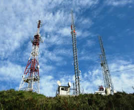 The track carries on upwards, seemingly getting ever steeper, still heading towards the red and white radio pylons, until you eventually you reach a junction at the top of the climb, with the pylons close by to your right.
It is then well worth taking a detour to your right up to the pylons themselves, at the 5 ¼ km point, in order to take in the views from here.
The track carries on upwards, seemingly getting ever steeper, still heading towards the red and white radio pylons, until you eventually you reach a junction at the top of the climb, with the pylons close by to your right.
It is then well worth taking a detour to your right up to the pylons themselves, at the 5 ¼ km point, in order to take in the views from here.
Then, retracing your steps, take the other turn, to the left, and, after a further brief climb, take the concrete road down to the valley below. The track then gets somewhat rougher, and at a T junction, marked by a black and white sign, take the route to the right, heading for the coast. Ahead of you, you will then see the brick-coloured houses of the Altos de Torrox development down below you, and eventually you will pass directly by these, to your right. Continue on down to the main Nerja-Torrox Costa road, at just before the 9 km point, at which you can either turn right to return to the start point of your walk (assuming you may have parked a car here), or left, back to Nerja itself.
Thus three possibilities exist for this walk. The first is to drive to Torrox Costa to the start of the walk and then to either conclude the walk by returning to Torrox Costa, as depicted on our map, above, (total distance 14 km).
The second is to use two (shuttle) cars, leaving one at Torrox Costa, and one at Nerja (or wherever you choose), and then conclude your walk by walking back to Nerja instead of to Torrox Costa. From hitting the main road, as above, it is just over 3 km to the centre of Nerja (in contrast to 5 km back to Torrox Costa), although it is a similar 5 km back to El Capistrano itself.
The third option is to start at El Capistrano, walk to Torrox Costa and then walk back to El Capistrano again after hitting the main road – total distance about 24 km. However the main road from Nerja to Torrox Costa isn’t all that great for walking, being fairly busy with traffic, and with no real place to walk, except by the edge of the road for most of the way.