Distance: 10 km Time: 3 hours Difficulty Rating: Medium to Difficult
MapMyWalk Link PDF Link (available to SpainAway guests)
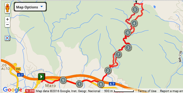
This walk heads north from Maro, mainly using old mule tracks, ascending the Rio de Miel valley, before doubling back again down the river gorge. It can be pretty rocky underfoot – mule tracks and dry river beds do tend to be! – and is a bit difficult to follow, although its original authors have added yellow paint splodges, and arrows, in addition to constructing stone cairns at key junctions. Its distance is just under 10 km, although this could of course be extended by some 6 km there and back, by starting your walk at El Capistrano, and then making your way to Maro in the way described in our Torre de Maro walk.
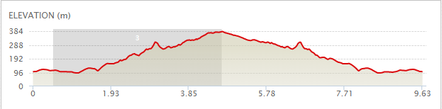
The map below shows the route in its entirety, with km markers inset, together with an indication of the elevation reached during the walk. You can also link to the online version of this map, located on the MapMyWalk website, with the ability to zoom in onto much finer details and so on, as described in our introduction. The link details are given above.
Assuming that you are starting from the car parking area at the entrance to Maro you need to then walk through the main street of the village, until emerging at its far end. At the end is a small roundabout. Go straight on here, signposted Almeria, and at the larger roundabout that follows almost immediately turn right onto the N340. Just over 1 km from the start of your walk you will see signs for ‘Camping’ and ‘Bungalows’ and, in a further 200 m, turn left onto a side road, the corner being marked with a small pyramid on its right hand corner, just before passing under some electric cables.
After a few hundred meters you will pass a villa named El Molino de Casanova on the right hand side of the road, and almost immediately take a left hand fork up a steep well concreted road. After crossing over the motorway below, continue straight on uphill, passing the white entrance way to the ‘Cortijo Samuel’ on your left. Bear right just after this gateway onto a much rougher track, crossed by a number of small ridges.
In a short distance, just after the 2 km point, you will come across a pile of gravel, with a track off to the right that leads to a now abandoned stone quarry that we shall actually explore on our way back. However here we now need to turn left to head up the hillside instead. Effectively you will be heading up a sort of dry stream bed here, veering over to the right, although it is easiest to first of all go left, and then right, taking a bit of a zigzag route. The route then passes along the right hand side of the hill, overlooking the quarry to your right, and passing along parallel to it. Continue along the path until you meet a water course on your left, complete with cairn. Veer right here and follow the path down, descending into a fairly wide dry stream bed.
Turn left up this stream bed for some distance, climbing over a fallen tree at one point, until reaching a path off to the right marked by cairns on the left hand side, and which is known as the Puente de Piedra Pass, which gives the walk its name. This is at around 3 ½ km.
 You will not be in any doubt that you have turned off at the correct point, since immediately after turning off from the stream bed you will pass under a dramatic natural stone bridge, the Puente de Piedra itself. Continue up the path until you come to a turn off to the left, identified by a pair of stone cairns, and yellow paint splodges, ascending what is reported as being an ancient mule track (wouldn’t have liked to be a mule in those days!).
After about ten minutes you will come to a point where a (dry) water course crosses the path, the route ahead being slightly barricaded off with rows of stones. Veer left here, following the faded yellow arrows, noting a large cave below and to your left as the route opens up to show you the countryside ahead. Then turn left at a fork complete with cairns and yellow paint splodges, and then cross a (dry) river bed, again well, signed with cairns and a yellow arrow. After some time you will then be faced with the remains of a metal fence, complete with ‘Beware of the Dog’ notice. You need to turn left beyond the fence, now on a much wider track, either by going around it to the fence’s left or right hand side. After a short distance a chain bars the track for vehicle access (with a further chain a short way ahead).
Turn to your left here, between these chains, down a wide dry stream bed. This is in fact the stream bed that you originally walked up, after passing the quarry. On the way down you will pass the rock bridge (Puente de Piedra) formation, this time on your left. Continuing on past the point that you originally joined this stream bed you will come to quite a steep drop, at which point you should bear right instead along a level path, taking you towards the abandoned quarry buildings and vehicles that can be seen ahead. This ‘graveyard’, full of abandoned machinery, vehicles etc, is quite interesting, and you should wind your way through it to the right. On the road leading out of the quarry area a huge Caterpillar bulldozer has been dumped to block off all entry. After maneuvering around this obstacle you will come out just before the Cortijo Samuel, at the pile of gravel from which you originally turned up the hillside, bordering the quarry. This is at around the 7 km mark. You now need to retrace your route down the hill, across the motorway, and back onto the N340, heading back to Maro.