Distance: 11 km Time: 4 hours Difficulty
Rating: Medium
MapMyWalk Link PDF Link (available to SpainAway guests)
This walk is one that we have devised ourselves, basing it around a number of old drover routes in the vicinity of Nerja. Needless to say a good proportion of the route is now comprised of concrete roads, created for the benefit of various fairly recently constructed villas, but the spectacular views remain, as also does, hopefully, its historical context.
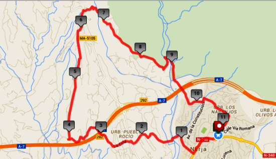
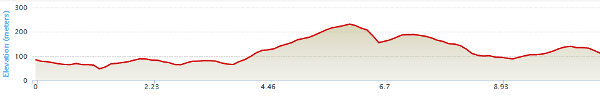
The map below shows the route in its entirety, with km markers inset, together with an indication of the elevation reached during the walk. You can also link to the online version of this map, located on the MapMyWalk website, with the ability to zoom in onto much finer details and so on, as described in our introduction. The link details are given above.
The early part of this route is identical to that at the beginning of the Arroyo del Puerto route, described elsewhere. Thus, starting, as usual, from the main entrance to El Capistrano Village, walk down the hill past the Supersol supermarket on your right until you reach the roundabout below. Continue a short distance down the main road, and then take the first turn to the right onto C/ Picasso. Follow this road as it quite quickly turns into a country road, descending steeply down to the bed of the Rio Chillar, below. From here we need to head towards the main road that leads up from Nerja to Frigiliana, and in order to achieve this we have introduced a little-known, although quite ancient pathway, that takes you directly to the point at which we actually want to cross the afore mentioned main road.
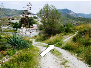
Thus, on reaching the Rio Chillar, just after 1 km, you will see immediately opposite to you, across the river bed, a pathway leading up the hillside opposite. Normally the river is shallow enough to just stride through here (especially if you are wearing walking boots). After crossing over here, take the concrete road route up the hill to the left, passing a red coloured house (No 12 Poniente). On reaching the top, bear right, still on the concrete road, for a further 30 metres, but where the main road turns right, go straight on along a rough track keeping to the right of a waymarker indicating the GP249 Senda de Malaga route. The track then narrows as it passes through a tree plantation, before dropping down into the bottom of the valley, and then going up the other side, eventually becoming a rough concrete path. Turn right at the top and continue through the urbanisation ‘El Cielo Exotica’, keeping straight on uphill.
Continue on until you reach the main Nerja-Frigiliana road with a roundabout, plus spire structure, at the top. Cross straight over at this roundabout, following the sign for Urbanisation Pueblo Rocio, on C/ La Colá. Continue on down the hill, ignoring turns off to the right, and, after cresting the next rise, continue on to a cross roads, at which you should turn right (directly opposite to the Box Nerja warehouse on your left). Continue along this road until you reach the motorway, overhead, at the 3 km point, where you should now take the underpass underneath the motorway. Almost immediately the road forks, and here you should bear left, onto a fairly rough road, passing the aforementioned Seacrest Kennels. Follow this track along for just over a km until you approach a double gateway on your left, bearing the image of a couple of dogs. You then need to turn right at this point, taking a dirt road up bythe hillside.
You are now on the ‘Camino Viejo de Malaga’ route (the ‘Old Malaga Pathway’), which takes you all the way up to the hamlet of La Molineta, just below Frigiliana. There is actually a minor choice of routes shortly after this point. Google Maps shows this route continuing on until it reaches a concrete road, servicing a large new villa, before turning off shortly before this to bypass it on its right. However the original Camino Viejo de Malaga route actually turns off onto a much rougher pathway before this, before re-joining the above variation just after it turns off the concrete road. On our own MapMyWalk version we have chosen to keep to this historically correct route, which, passing as it does along a high ridge, affords much more interesting views to either side.
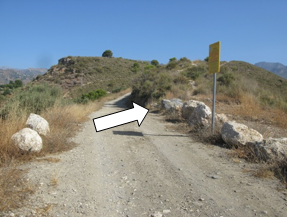
Thus, to follow the historic route, take a rough track off to the right located about 200 metres from the starting point of the ‘dog gates’, and just after a yellow ''Ayuntamiento de Nerja' sign, as shown above, left, continuing up along the ridge along quite a rough track, passing the large villa mentioned above on your left. Continuing along this path, with some splendid views off to your right, you will come to a junction by a further large villa, at which you should turn right. The track eventually turns into a concrete road, heading uphill, and then reaches a junction at which you should turn left. On the wall just before this junction, to your right, is a street sign indicating that you have indeed come up the Camino Viejo de Malaga. At the top of this road, just past a series of rubbish and recycling bins, together with a bank of post boxes, for the Las Lomas Urbanization you will reach the main Nerja – Frigiliana road once more, just above La Molineta.
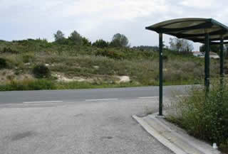
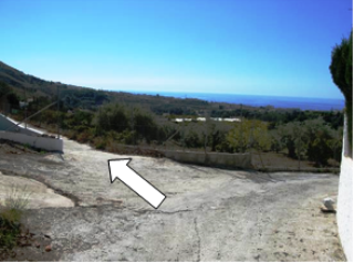
From here you can of course simply turn left at the top and walk down the main road into La Molineta, although there isn’t actually any sort of pavement area to keep to. However we have researched a very small diversion that actually takes in a further historic feature, in keeping with the overall flavour of this route. Thus on reaching the main road, cross right over by the bus stop, shown above right, taking a rough path up the hillside to your left, the entrance to which is marked by a blue paint splodge. The path soon broadens out considerably, and reaches a T-junction at which you should turn left. Continue along this path, as it begins to wind down towards La Molineta.
Before you reach here, however, you will see a rough track off to your right, picture below left. Only a few metres up here you will reach the remains of an ancient threshing floor one of the few relics of the area’s ancient agricultural past. From here you can also see some excellent views, including ahead to the valley that you are shortly to descend into. Retracing your steps you continue down the track into the hamlet of La Molineta itself. Just to your left here is a small roadside café where you can enjoy a drink or snack. At this point we join the second of our ancient drover routes – La Camino de La Molineta.
Then simply turn right at the bottom of the track down from the threshing floor, heading down a steep road to the valley below through which runs the (almost always dry) bed of the Rio Higuerón. At the bottom, as you leave the concrete road, most routes take you either left up the river bed in the direction of Frigiliana, or right in the direction of Nerja, but we shall continue to follow this ancient route straight ahead, crossing the river at right angles, and immediately heading uphill. After continuing to follow this road for some distance you will reach a junction at which we join up with our ‘Cruz de Pinto’ route, albeit heading in the other direction. Our present route takes us on down the hill at this point, bearing right, and hence reversing the Cruz de Pinto route. However if you wished you could turn left here, shortly afterwards heading right up the hillside to the shrine itself. You could then descend back to your start point, below (via a slightly different route), and continue with the current walk. For details of this diversion we recommend that you consult the Cruz de Pinto route details themselves.
On following this road down, you will eventually reach a number of dwellings, and at the junction shown above right should effectively go straight ahead (bearing slightly left), then following the road around to the right until it re-joins a more major road, at which point you should turn left. Continue on down this road, at one point sweeping around to your left. Continue on down until you reach the bed of the Rio Chillar, and turn right here, heading back towards Nerja. At a junction ahead, take the left fork up the hill, and continue on up here until approaching the top of the hill just below San Juan. Continue straight on here, turning left up to San Juan at the end of C/ Mirto, and then right onto the road skirting the bottom of San Juan, and onto Camino de Ronda at the top end of El Capistrano Village, from where you can descend to your start point.