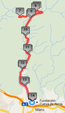
Distance: 14 km Time: 4 hours Difficulty Rating: Easy
MapMyWalk Link PDF Link (available to SpainAway guests)
 This walk is based on Elma’s Thompson’s NE/17 walk from the entrance to the Caves to the El Pinarillo picnic area north of here, together with an extension to the Fuente del Esparto, or Fountain of the Esparto Grass (which is a coarse grass with tough narrow leaves, native to Spain and North Africa, and which is used to make ropes, wickerwork, and high-quality paper).
The route is pretty straightforward, but, unfortunately, it is an almost exact number of km in length – 14 – and its turning point is therefore right on the 7 km mark. This means that the outgoing km markers overlap with the returning ones. Thus ‘14’ is the same as ‘0’; ‘13’ the same as ‘1’, and so on, up to ‘8’ being the same as ‘6’.
As described here it is a there-and-back walk, but this is no downside in an area as beautiful as this, with spectacular views, and the experience coming down from the top is quite different to that going up.
Its total length, including the extension, is 14 km, although you could make it significantly longer by getting to Maro on foot (either by simply walking out along the N340, or by taking our Cuevas de Nerja route described elsewhere). This would add a total of 6 km to the trip, there and back.
You can also link to the online version of this map, located on the MapMyWalk website, with the ability to zoom in onto much finer details and so on, as described in our introduction. The link details are given above.
After reaching the entrance to The Caves, and its associated external car park, simply take the track heading north into the hills, signed ‘Area Recreativa El Pinarillo, 5 km’. Its route is not too steep, and although a trifle stony underfoot, is in fact drivable all the way, and hence it is possible to shorten its length by parking, for example at El Pinarillo, or indeed at a suitable spot further on. The route leads northwards, passing the Barranco de la Coladilla to your left, deep down in the valley. About halfway to the picnic site a track goes off to the right, just before the 3 km mark. This is the beginning of the route up to the top of the highest mountain in the Almirajas – El Cielo (or ‘Heaven’). A trip to make on another occasion!
The picnic site itself – El Pinarillo – at just over 4 ½ km, is a popular destination with the local Spanish at weekends. The site is really well-equipped, with built-in BBQ stands, a water supply, and so on. There is also a children’s recreation area and a café (Although this is only open on occasion). From here you can continue up the track, signposted Fuente de Esparto. After a short dip down, at the bottom of which you cross the barranco, you then climb up to the fountain itself.
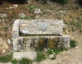 Don’t be disappointed if you were expecting the fountain itself, at about 6 ½ km, to be a huge and majestic structure, dating back to antiquity. The spring that feeds it was re-constructed as recently as 1994, as the plaque on the back wall of the fountain relates, and is certainly regarded a quite drinkable. Slightly beyond the fountain are some newly constructed buildings, including a small café, although its opening times are not documented. It is worth continuing on up the hill for another km or so until you reach the summit of the ridge, with some splendid views to the valley below. In order to reach the absolute peak you need to take a track to the left which is comprised of some quite loose stones, which are easy enough to climb up on, but somewhat slippery on the descent, so that walking poles will be a help here. The views from the summit are quite spectacular.
There are actually several routes down that you could take from here, including one straight ahead down into the valley in front of you, ending up in Nerja, one off to the right that takes you to Frigiliana, and also one taking much rougher tracks in the area of the barranco that parallels your route up, but we would prefer to keep this route as one that is doable by all. Hence you now simply need to retrace your previous steps, to return to the entrance area of the Caves.