Distance: 8.5 km Time: 3 hours
Difficulty Rating: Medium
MapMyWalk Link PDF Link (available to SpainAway guests)
This walk, which is based almost entirely on Elma Thompson’s FR/07 walk, is a further almost 9 km trek through rolling countryside to the north west of Frigiliana. As always, it begins at the roundabout on the ring road, just below the El Ingenio sugar factory, then heading for the other, north western, end of the old town, before briefly heading out north on the Frigiliana-Torrox road (MA 5105). Although you can also reach this far point by taking a more attractive route through the centre of the old town, on its only driveable stretch, C/ Real, in this instance we have chosen simply to take you out along the ring road, below the village.
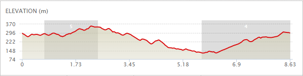
The map below shows the route in its entirety, with km markers inset, together with an indication of the elevation reached during the walk. You can also link to the online version of this map, located on the MapMyWalk website, with the ability to zoom in onto much finer details and so on, as described in our introduction. The link details are given above.
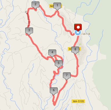
Thus from the roundabout below El Ingenio, you just need to continue left along the ring road, until reaching the roundabout at the far end. We then head out north along the main road to Torrox, almost immediately taking a turn off to the left by the side of the Restaurante Santo Cristo. The road then winds around a valley passing through avocado plantations, passing a group of houses on the left, named as Casa Tejar Alto, which was originally a sugar mill, and then an olive mill. Further along there is a rough track off to the right, with a goat farm on your right, and then further up there is a road off to the right which is where a route known as the Puerta Verde heads out (up a very steep, and barely walkable hillside). We continue along the main road though, and after passing the Hotel Rural La Posada Morisca on your right, you eventually climb up to a crossroads on top of the ridge, well worth stopping at to take in some excellent views, including one back towards Frigiliana..
 At these crossroads you should turn left, and follow the ridge along, on what used to be the Loma de la Cruz pathway (but is now a concrete road, as is the whole of the journey, servicing, as it does, a variety of villas and cortijos). Most of the old cortijos that were all that was to be found here historically have now been rebuilt, but there are still the ruins of one or two still to be discovered. The track then rises up to a tall mast and a large depósito (water tank) by a crossroads, where you want to continue straight on. After descending a short way you will come to a Y-junction, where you want to turn right (it is at this point that the ‘Arroyo de los Bancales’ route comes in). Follow this route down all the way, until reaching a junction with a number of direction signs off to the right hand side. However you need to continue straight ahead here, up the hill, heading towards the Nerja-Frigiliana main road, just above La Molineta.
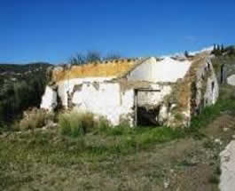
After a while the track passes the restored Cortijo de la Casilla (with an interesting ruin just behind), together with a number of other attractive dwellings. Eventually you will reach the main road up to Frigiliana, lying just above the hamlet of La Molineta. Turn left at this junction, up the hill, noting the splendid views to your right, across the valley, picture below left, before reaching the roundabout at the entrance to the new village, where you should take the left hand route, or ring road, picture below right, taking you back to the start point of your walk. Turn left at this junction, up the hill, noting the splendid views to your right, across the valley, before reaching the roundabout at the entrance to the new village,, where you should take the left hand route, or ring road, taking you back to the start point of your walk.