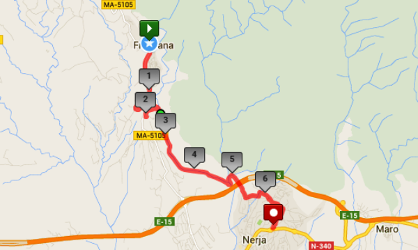
via La Molineta and Rio Higuerón
Distance: 7 km Time: 2 1/2 hours Difficulty Rating: Easy
MapMyWalk Link PDF Link (available to SpainAway guests)
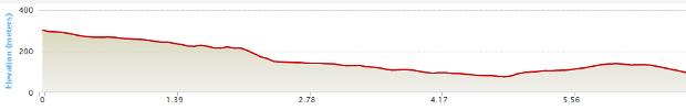
This is essentially the exact reverse of the Nerja - Frigiliana (1) route. Thus from the start point of the roundabout just below the old sugar factory, take the ring road along to the roundabout at the entrance to the new village. From here you can continue on down the main Frigiliana – Nerja road until you reach the hamlet of La Molineta on your left.
However a slight deviation is possible, just above La Molineta, that cuts off a large corner of the main road (and avoids 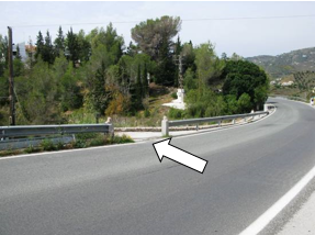 the fact that there is no pavement to walk on during this stretch), wherein you turn left just before the final sweeping bend, picture left. The track then winds down for something like 200 m, before re-joining the main road just before La Molineta itself. Here you need to go left. On entering La Molineta you are then essentially aiming to bear left and then go straight ahead down a steep road to the valley below. However you might just like to take a very brief diversion off to your right, up to the site of an interesting old threshing floor. To reach this point go up past a concrete pole and two electricity pylons, and then turn left up a white gravel track just before a house. From the threshing floor, there are some great views to be seen.
On returning into the centre of La Molineta you now need to turn right, heading down a steep hill to the valley of the Rio Higuerón down below. On reaching the valley bottom, turn right, following the river valley ignoring all turns off, until you reach the confluence with the Rio Chillar, just before the motorway. On reaching the above confluence, you now need to turn left, up by the northern side of the Chillar (you can either cross it at the vehicle ford, or go a few metres downstream and cross at a concrete culvert), taking a road off to the right after a short distance, at a point where you will see both a ‘Parking’ and a ‘No Entry’ sign. After a few metres take the right hand at the junction reached and turning right at the T-junction at the top then climb back out of the valley. Once you reach the summit, by a line of pylons, turn left at the end of C/ Mirto, and then right onto the road skirting the bottom of the San Juan urbanisation, and onto Camino de Ronda at the top end of El Capistrano Village, back to the Nerja start/end point.